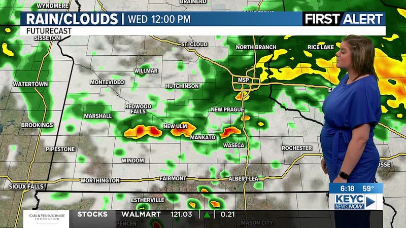
Rain chances return tonight, Wednesday; temps to remain cool
Showers & t-storms possible tonight and throughout Wednesday with temperatures remaining on the cooler side.
We will see sunshine mixed in over the next few days despite looking at showers and possible thunderstorms between Tuesday night and throughout Wednesday. Temperatures will remain cooler with highs mainly in the 70s through the rest of this week and upcoming weekend.
Today will start off with cloudy skies and a few lingering rain showers possible before clearing up leading to mostly sunny skies for the early to mid-afternoon hours. Temperatures will slowly rise into the mid-70s by this afternoon with winds starting off breezy between 15 and 25 mph and slowly calming down to between 5 and 10 mph through this evening. Clouds will return through the mid to late-afternoon hours leading to mostly cloudy skies as rain chances return anytime after 8 pm this evening. They will start off rather light and isolated before teetering between widely scattered and scattered after midnight, continuing into Wednesday morning as temperatures drop into the upper-50s.
Wednesday will then teeter between partly cloudy and mostly cloudy with lingering morning showers possible, a break from rain chances, then more widely scattered showers and thunderstorms possible through the afternoon into the evening hours. Temperatures will continue to top out in the mid-70s with winds on the stronger side, hovering between 20 and 30 mph, gusts up to 40 mph possible. Showers and thunderstorms will slowly fizzle out through the evening hours leaving behind partly cloudy skies that will eventually clear up, making way for mostly clear skies by Thursday morning as temperatures drop into the low to mid-50s overnight.
Thursday is looking to be on the quieter side with mostly sunny skies and a light breeze. Temperatures are projected to top out in the low-70s with winds hovering around 15 mph, gusts up to 25 mph at times possible. Thursday night will remain mostly clear and quiet as temperatures drop into the low to mid-50s by Friday morning.
Friday will start off mostly sunny and quiet. We are looking at a highs topping out in the mid-70s with winds between 5 and 15 mph across the area. Thursday night will become partly cloudy with a few late night to overnight showers possible as temperatures drop into the upper-50s by Saturday morning.
Saturday and Sunday will teeter between partly cloudy and mostly cloudy with temperatures hovering in the upper-70s both afternoons as winds average between 5 and 15 mph, occasional gusts up to 20 mph possible. There is a chance for a few stray showers possible throughout Saturday, but Sunday is currently looking to be drier/quieter. Overnight temperatures are anticipated to drop into the low-60s by Sunday morning and the upper-50s by Monday morning.
Next week is looking to continue with partly cloudy skies through Wednesday with mostly sunny skies returning by Thursday. Temperatures will remain in the upper-70s through the week with winds averaging between 5 and 15 mph and occasional gusts up to 20 mph possible at times. Rain chances as of right now are looking to remain minimal with just a stray shower or two here and there. Overnight temperatures are projected to drop into the low-60s by the following mornings.
Click here to download the KEYC News Now app or our KEYC First Alert weather app.
Copyright 2026 KEYC. All rights reserved.