Post severe storm clean up: Foggy but quieter day ahead
Post severe storm clean up continues today as fog blankets the area with quieter conditions mixed in.
Severe weather has come and gone through the area leaving behind a mess for the residents of the area to clean up after. Thankfully today will be a quieter day despite a foggy morning and isolated rain chances possible.
The Storm Prediction Center (SPC) has put out their storm reports from Monday, April 13, 2026, and showed there were 140 total severe weather reports across the country. Most of those came from the southern Minnesota, northern Iowa, and southern to central Wisconsin areas. Reports varied between damaging winds, hail to large hail up to 2 inches or more in diameter, and several tornadoes in the area.
Thankfully, today is going to be on the quieter side overall despite some foggy conditions through the morning hours and isolated rain chances possible. Isolated showers will be possible in portions of the area this morning and afternoon with a few isolated thunderstorms possible this evening and tonight. Temperatures will hover in the mid to upper-60s by this afternoon with relatively light winds between 5 and 15 mph. Tonight, temperatures will drop into the mid to upper-40s with a few isolated thunderstorms possible after midnight.
Wednesday will then be partly cloudy with morning showers and a few thunderstorms possible that will fizzle out through the early to mid-afternoon hours. Temperatures will then rise into the upper-60s with winds hovering between 5 and 15 mph. As showers and thunderstorm chances fizzle out through the mid-afternoon hours, skies will gradually become mostly clear with temperatures dropping into the upper-40s by Thursday morning.
Thursday will then be mostly sunny and pleasant. We are looking at highs in the mid to upper-70s with a pleasant breeze between 10 and 15 mph, gusts up to 20 mph possible. Thursday night will become partly cloudy as temperatures drop into the upper-50s by Friday morning.
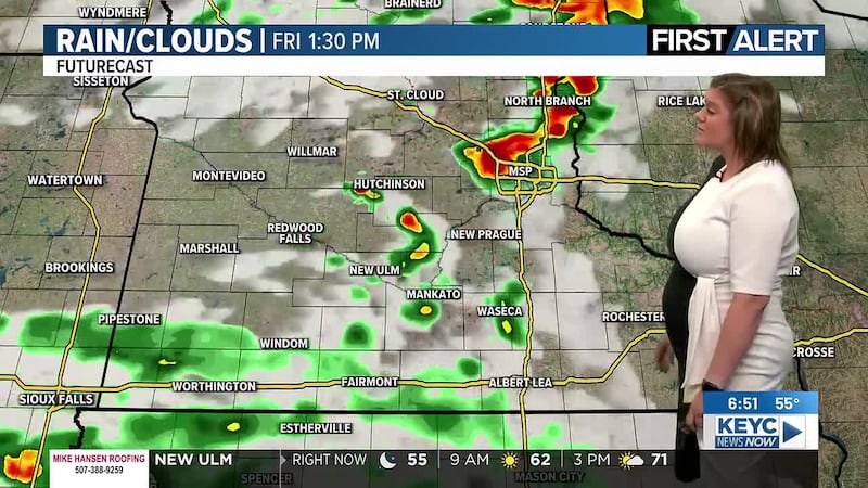
A cold front is projected to move through the area on Friday bringing cloudy skies with showers and thunderstorms possible. Temperatures will top out in the mid-70s with winds hovering between 20 and 25 mph, gusts up to 35 mph possible before the cold front moves through. At this time, we are not looking at severe weather in the area on Friday despite the cold front moving through. Showers and thunderstorms will develop through the afternoon hours and carry over into the overnight hours, possibly becoming mixed with snow at times while temperatures drop following the passage of the cold front. Once the front moves through, temperatures are projected to drop into the mid-30s by Saturday morning with snow mixing in with the rain overnight.
Saturday will start off with a lingering rain/snow mix before that fizzles out through the afternoon hours. Temperatures will be cooler with highs topping out in the low-40s and winds hovering between 20 and 30 mph, gusts up to 40 mph possible. Saturday night will gradually become mostly clear as temperatures drop into the upper-20s by Sunday morning.
Sunday will remain on the cooler side despite mostly sunny skies across the area. Temperatures will top out in the upper-40s with winds hovering between 10 and 15 mph, gusts up to 20 mph possible. Sunday night will remain mostly clear as temperatures drop into the low-30s by Monday morning.
Next week is going to start off on the quiet side with temperatures slowly warming up and mostly sunny skies mixed in throughout Monday and Tuesday. Temperatures will hover in the low-60s on Monday before rising into the mid-60s by Tuesday afternoon. Winds will remain on the breezy side, hovering between 15 and 25 mph with gusts between 30 and 40 mph over the two days. Overnight temperatures are projected to drop into the low to mid-40s by Tuesday morning and the low-50s by Wednesday morning.
From there, we are looking at partly cloudy to mostly cloudy skies returning throughout Wednesday, sticking around through Thursday with more showers and thunderstorms possible between the two days. Temperatures will continue to remain on the warmer side, hovering in the mid-60s on Wednesday and the upper-50s on Thursday. Winds will remain breezy, hovering between 15 and 20 mph with gusts up to 25 mph possible both days. Overnight temperatures are projected to drop into the mid-40s by Thursday morning and the low-40s by Friday morning.
Click here to download the KEYC News Now app or our KEYC First Alert weather app.
Copyright 2026 KEYC. All rights reserved.