Summer like weather today; strong to severe storms possible Thursday
Highs in the 80s today with a chance of strong to severe storms possible Thursday.
Another summer like day lies ahead of us before a chance of strong to severe storms returns by Thursday afternoon/evening.
Today will be full of sunshine and warmth with a pleasant breeze mixed in. We are looking at highs topping out in the mid-80s by this afternoon with winds hovering between 15 and 25 mph, with gusts between 30 and 35 mph possible across the area. If you plan to spend time outside today, be sure to use that sunscreen as we are looking at a high UV index at a level 6. This means a sunburn can start occurring in as little as 20 to 25 minutes. The peak time for the max UV rays to reach us will be between 11 am and 3 pm. Clouds will gradually increase across the area through tonight making way for mostly cloudy skies by tomorrow morning as temperatures drop into the low-60s.
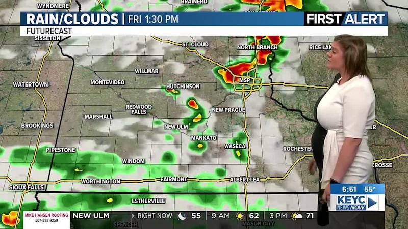
Tomorrow, we are looking at a cloudy start to the day with temperatures slowly rising into the low-70s by the mid-afternoon hours. Winds will remain on the stronger side, hovering between 15 and 25 mph, gusts up to 35 mph possible. Light, spotty showers will start to develop between the early to mid-afternoon hours ahead of a line of showers and thunderstorms with a passing cold front move through the area. Thunderstorms are anticipated anytime after 6 pm with a few strong to severe storms possible. All modes of severe weather are possible, this means we could see damaging winds/gusts, large to very large hail, and even a few tornadoes in the area. The severe threat will slowly diminish through the evening hours, becoming less severe after 9 and 10 pm despite lingering showers and a few lingering thunderstorms possible, which will gradually clear up between 11 pm and 1 am. Rain totals will be lightest to the west with up to a quarter of an inch possible, increasing the more east you head, with up to an inch or so possible along and east of I-35 in both southeastern Minnesota and northeastern Iowa. Once the cold front moves through, temperatures will start to drop, eventually reaching the mid-40s by Friday morning with gradual clearing overnight.
By Friday morning, we should see mostly sunny skies return to the area. Temperatures will be slightly cooler, more seasonal with highs topping out in the low-60s by the afternoon hours as winds hover between 10 and 15 mph, gusts up to 20 mph possible. Friday night will become partly cloudy with temperatures dropping into the low-40s by Saturday morning.
This weekend will be relatively seasonal with partly cloudy skies on Saturday and mostly cloudy skies by Sunday. Saturday could have a few isolated showers to a stray thunderstorm or two possible, with more scattered chances for showers and thunderstorms possible throughout Sunday. Temperatures will hover in the low-60s both afternoons with winds between 10 and 20 mph, gusts between 20 and 30 mph across the area. Saturday night will become mostly cloudy with a stray shower or two possible as temperatures drop into the mid-40s by Sunday morning. Sunday night will continue with mostly cloudy skies and lingering showers and thunderstorms possible as temperatures drop into the upper-40s by Monday morning.
Monday will then start off with lingering showers and thunderstorms through the morning and early to mid-afternoon hours before rain wraps up for the day. Skies will then remain mostly cloudy as temperatures hover in the mid-50s through the afternoon hours and winds increase back up to 20 to 25 mph, gusts up to 30 mph possible. Monday night will remain mostly cloudy and breezy as temperatures drop into the low-40s by Tuesday morning.
Tuesday will then continue with mostly cloudy skies and isolated rain chances, a stray thunderstorm or two possible. Temperatures will hover in the mid-50s with winds between 10 and 15 mph, gusts up to 25 mph possible. Isolated rain chances may continue into the overnight hours as temperatures drop into the low-40s by Wednesday morning.
We could see more scattered showers with a few thunderstorms possible throughout next Wednesday with mostly cloudy skies sticking around. Temperatures will hover in the upper-50s with winds between 10 and 15 mph, gusts up to 20 mph possible. Showers and thunderstorms may continue into the overnight hours as temperatures drop into the low-40s by Thursday morning.
Thursday will remain mostly cloudy with a stray shower or two possible. Temperatures will continue to hover in the upper-50s with winds hovering between 10 and 15 mph, gusts up to 20 mph possible. Thursday night will gradually become partly cloudy as temperatures drop into the low-40s by Friday morning.
Friday of next week will then be partly cloudy and quiet with a light breeze sticking around. We are looking at highs in the low-60s with winds between 10 and 15 mph, gusts up to 20 mph possible. Friday night will remain partly cloudy and quiet as temperatures drop into the low-40s by Saturday morning.
Click here to download the KEYC News Now app or our KEYC First Alert weather app.
Copyright 2026 KEYC. All rights reserved.