Strong to severe storms possible this afternoon
Cold front to fire up strong to severe storms around the area.
A cold front moving through the area will not just drop temperatures heading into the weekend, but bring us a chance of strong to severe storms across the area this afternoon and evening.
SPC Severe Risk Today

Both southern Minnesota and northern Iowa (and areas south and west of there) are under a medium threat, or level 2 of 5, for strong to severe storms. The biggest threat for the area will be damaging winds and/or gusts up to 60 mph or greater through this afternoon. The hail threat is also considered medium, but covers a slightly smaller portion of the area than the wind threat, with up to 1 inch hail in diameter possible. Some of us could see up to 2 inches or greater; however, the greatest threat for the larger hail stones would be south of Sioux City, Iowa. The tornado threat is very low for the area, however, with the threat increasing across westcentral to southwestern Iowa, we cannot rule out the chance of a spin up or two around southern Minnesota and/or northern Iowa (despite the risk being rather low).
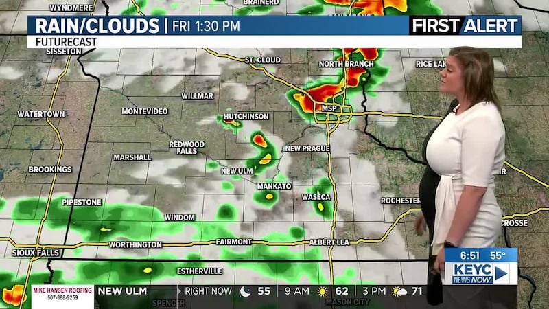
Storms will start developing along and just ahead of a passing cold front, starting between 12 pm and 4 pm this afternoon. From there, the line of storms will be strongest along the leading edge of the cold front, meaning the severe threat will diminish as the leading edge passes through the area. This is also where you could see the strongest winds, heaviest rains, hail, and the possibility of a spin up or two occurring. As the front moves through, you will likely notice a shelf cloud becoming more prominent as the line of storms becomes more organized across southcentral and northcentral Iowa between 4 pm and 6 pm this afternoon. From there, the cold front and leading line of thunderstorms will move eastward, crossing the I-35 corridor between 7 pm and 9 pm tonight, leaving behind a few lingering showers and thunderstorms in the area, which will gradually clear up shortly after midnight.
Before the front moves through, temperatures will hover in the upper-60s and low-70s across the area with breezy winds mixed in. After the front moves through, temperatures will hover in the mid to upper-60s through the rest of this afternoon and evening, eventually dropping into the low-40s by tomorrow morning.
Tomorrow will be quieter and cooler despite mostly sunny skies across the area. We are looking at highs hovering in the low-60s with winds hovering between 10 and 15 mph, gusts up to 20 mph possible. Tomorrow night will gradually become partly cloudy to mostly cloudy as temperatures drop into the low-40s by Saturday morning.
Saturday will then be mostly cloudy with pockets of sunshine possible along with a few scattered showers through the morning and afternoon hours. Showers will then clear up through the afternoon with temperatures topping out in the low-60s and winds hovering between 5 and 15 mph. Saturday night will remain mostly cloudy with temperatures dropping into the mid-40s by Sunday morning.
Sunday will continue with mostly cloudy skies as a minor, secondary cold front moves through the area. As of right now, we are not looking at strong to severe storms in the area on Sunday. Instead, we are looking at general showers and thunderstorms possible with temperatures hovering in the mie-60s through the afternoon hours. Winds will be breezy, averaging between 15 and 20 mph, gusts up to 30 mph possible. Showers with a few thunderstorms possible will continue overnight into Monday morning as temperatures drop into the low-50s.
The secondary cold front will lead to cooler temperatures by Monday afternoon with lingering showers and thunderstorms possible through the morning and early to mid-afternoon hours before wrapping up for the day. Temperatures will likely hover in the upper-50s with winds hovering between 15 and 25 mph, gusts up to 30 mph possible. Skies will remain mostly cloudy through the late night and overnight hours as temperatures drop into the low-40s by Tuesday morning.
From there, Tuesday through Saturday of next week/weekend will teeter between partly cloudy and mostly sunny with a chance of showers and thunderstorms possible Thursday night into Friday morning and throughout Friday and Friday night. Temperatures will hover in the mid to upper-50s Tuesday through Friday with the low-60s returning by Saturday of next weekend. Winds through the middle to end of next week will be on the breezy side, averaging between 10 and 20 mph, gusts between 20 and 30 mph possible. Overnight temperatures will likely drop into the mid to upper-30s and low-40s by the following mornings.
Click here to download the KEYC News Now app or our KEYC First Alert weather app.
Copyright 2026 KEYC. All rights reserved.