Seasonal weekend, increasing rain chances on the way
Highs mainly in the 60s this weekend with rain chances possible Saturday and Sunday.
Temperatures have returned to seasonal (or average for this time of year) following Thursday’s cold front. Despite the more seasonal temperatures, we will see a mix of sunshine today with rain chances returning gradually throughout the weekend between Saturday and Sunday.
Today will be quiet and mostly sunny with seasonal temperatures. Seasonal for this time of the year is anywhere in the low-60s, and we are looking at a high of 62 by this afternoon with light winds between 5 and 10 mph across the area. Tonight will gradually become mostly cloudy after midnight as temperatures drop into the low to mid-40s by Saturday morning.
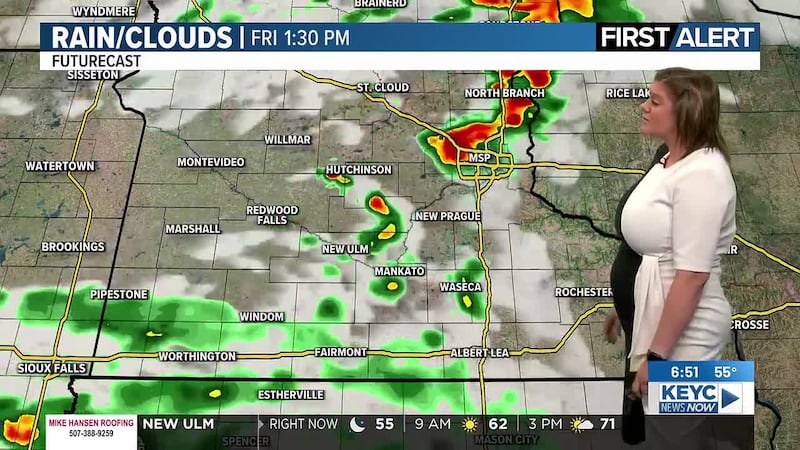
Saturday will be mostly cloudy with spotty rain chances for southcentral to southeastern Minnesota and across northcentral to northeastern Iowa. Areas west and northwest of Mankato are looking at more scattered rain chances throughout the day. This means not everyone will see rain around the area tomorrow, some of us will stay dry. Temperatures will remain seasonal, hovering in the low-60s with winds between 5 and 15 mph across the area. Saturday night will continue with mostly cloudy skies and a few lingering showers possible in portions of the area as temperatures drop into the upper-40s by Sunday morning.
Sunday will remain mostly cloudy with isolated rain chances throughout the morning and afternoon hours. Temperatures will be on the warmer side, hovering in the upper-60s and low-70s across the area. Winds are projected to increase, hovering between 15 and 20 mph, gusts up to 30 mph possible. Rain chances will become scattered throughout the late night hours, eventually becoming widespread and slightly heavier in intensity throughout Sunday night into Monday morning as temperatures drop into the low to mid-50s.
Monday will then start off with widespread showers continuing across the area before slowly fizzling out throughout the evening and early night hours. Temperatures will return to seasonal, hovering in the low-60s through the afternoon with winds on the strong side, hovering between 20 and 25 mph, gusts up to 40 mph possible. Showers are projected to slowly wrap up through the early night hours, leaving behind mostly cloudy to partly cloudy skies overnight as temperatures drop into the low-40s by Tuesday morning.
These rain chances through the upcoming weekend and early next week will leave us with an additional 1-2 inches of rain across southern Minnesota and northern Iowa once it has wrapped up across the area.
From there, the rest of next week is looking to be on the quieter side as far as rain chances go. Skies will teeter between mostly sunny and partly cloudy through the middle to end of next week and next weekend. Temperatures will be on the cooler side, hovering between the mid-50s and low-60s. Winds throughout next week will be on the breezy to windy side, averaging between 10 and 20 mph with gusts between 20 and 30 mph at times. Overnight temperatures will also be on the cooler side, dropping into the mid to upper-30s and low to mid-40s by the following mornings.
Click here to download the KEYC News Now app or our KEYC First Alert weather app.
Copyright 2026 KEYC. All rights reserved.