Showers, t-storms today: Quieter, seasonal conditions follow
Widespread showers, t-storms today followed by quieter conditions with relatively seasonal temps mixed in.
Grab those umbrellas before heading out the door today as showers are expected to become widespread with some embedded thunderstorms mixed in at times. The good news is, once that rain wraps up, the rest of the week will be on the quieter side despite a few isolated rain chances in the mix and relatively seasonal temperatures hovering from the mid to upper-50s into the mid-60s.
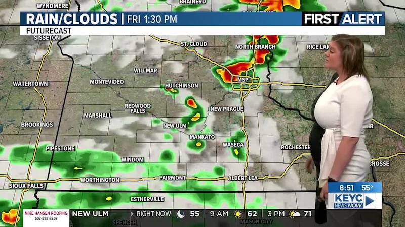
Live Radar Loop

There is a low threat of strong to severe storms for today, which means we could see a couple of stray strong to severe storms possible with damaging winds and large hail possible. The threat of a tornado is rather minimal, nearly nonexistent but can’t fully be ruled out as an isolated spin up may be possible. Temperatures will top out in the low-60s through the early afternoon hours as winds hover between 10 and 20 mph. Showers and thunderstorms are projected to wrap up between 4 pm and 6 pm, leaving behind cloudy skies for the remainder of the day. Tonight, skies will gradually become mostly clear after midnight as temperatures drop into the upper-30s by tomorrow morning.
SPC Severe Risk Today

Tuesday will start off with some morning sunshine before clouds thicken back up heading into the late morning and early afternoon hours. From there, skies will be mostly cloudy as temperatures top out in the mid-50s and winds hover between 10 and 20 mph across the area. Tuesday night will remain mostly cloudy with a few isolated rain chances possible before clearing up by early Wednesday morning as temperatures drop into the mid to upper-30s.
Wednesday through Friday of this week will then remain rather quiet with skies teetering between mostly sunny to partly cloudy. We are looking at remaining dry aside from a few isolated showers possible between Wednesday and Thursday, though not everyone will see these isolated rain chances. Temperatures between those days will hover in the mid to upper-50s with winds between 5 and 15 mph, occasional gusts up to 20 mph possible. Overnight temperatures will remain on the chillier side, dropping into the mid to upper-30s by the following mornings.
This coming weekend, Saturday and Sunday, will be on the warmer side with mostly sunny skies on Saturday and partly cloudy skies and a few isolated showers possible on Sunday. Temperatures over the weekend will hover in the mid to upper-60s both afternoons with winds between 5 and 15 mph across the area. Overnight temperatures will also be slightly warmer, dropping into the mid-40s by the following mornings.
Next week will continue with quieter conditions and partly cloudy skies for Monday and Tuesday and mostly sunny skies by Wednesday. Temperatures will remain on the seasonal side, hovering in the low to mid-60s with winds between 10 and 15 mph, gusts up to 20 mph possible. Overnight temperatures will likely drop into the low to mid-40s by the following mornings.
Click here to download the KEYC News Now app or our KEYC First Alert weather app.
Copyright 2026 KEYC. All rights reserved.