Areas of frost possible next few nights, warm up on the way!
Chilly overnight temperatures could lead to areas of frost ahead of weekend warm up.
Overnight temperatures are projected to drop into the 30s, leading to areas of frost possible the next few nights. These cooler temperatures won’t last much longer, as more seasonal temperatures are expected to return through this coming weekend and next week.
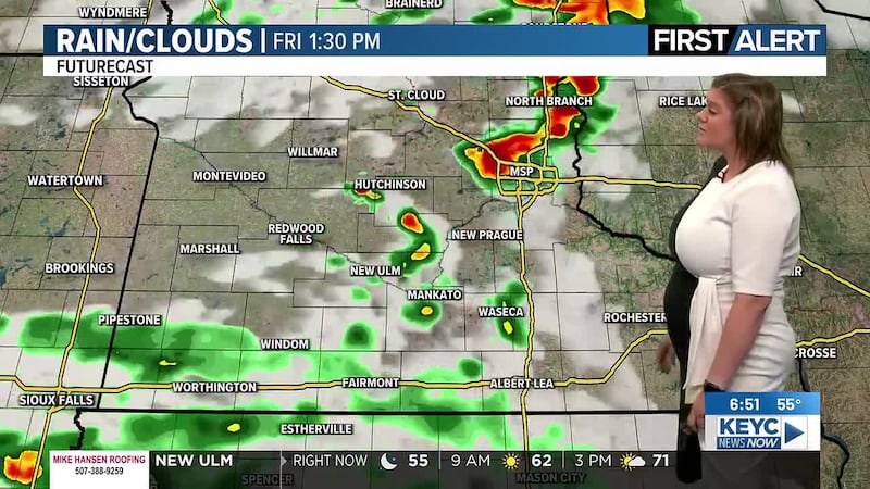
Conditions overall will be generally quiet despite a few sprinkles possible here and there this afternoon, tonight, and possibly Thursday afternoon. Though, these sprinkle chances will be only that with little to no rain accumulation expected anywhere in the area. Today through Friday afternoon will remain on the cooler side with highs hovering in the low to mid-50s across the area. Winds will be rather light, hovering between 5 and 15 mph, occasional gusts between 20 and 25 mph possible.
Areas of frost are possible tonight, Thursday night, and Friday night due to chilly overnight temperatures expected. We are looking at those temperatures dropping into the mid-30s overnight between tonight and Friday night, leading to the possibility of frost developing around the area. This could pose some problems to those of you who have gotten a head start on planting sensitive flowers and other vegetation. If you have gotten that head start, it is recommended to cover those plants/vegetation with blankets and/or bring them inside if possible. This helps keep them warm and can prevent frost from developing on these plants/vegetation.
The good news is, a return to seasonal conditions will return through this weekend as temperatures warm up into the low to mid-60s through Saturday and Sunday afternoons. Winds will remain relatively light, between 5 and 15 mph, occasional gusts up to 20 mph possible. Skies will teeter between mostly sunny and partly cloudy with quiet conditions continuing through the weekend. Overnight temperatures Saturday are projected to drop into the mid-40s by Sunday morning, and overnight temperatures Sunday are expected to drop into the mid-40s by Monday morning.
Next week will remain on the seasonal side, with a mix of sunshine and cloud coverage across the area. We could see a few isolated showers possible on Monday morning, Tuesday night, and possibly Wednesday afternoon. Keep in mind these are very minor rain chances, and even if they remain in the forecast as we head into and through next week, not everyone will see these chances of rain as they are expected to be spotty/isolated.
Temperatures through next week are expected to hover in the low to mid-60s Monday through Wednesday, the upper-50s on Thursday, and the low-60s next Friday. Winds throughout the week will average between 10 and 20 mph with gusts between 20 and 30 mph possible. Overnight temperatures will also remain warmer, more comfortable, dropping into the low to mid-40s by the following mornings.
Click here to download the KEYC News Now app or our KEYC First Alert weather app.
Copyright 2026 KEYC. All rights reserved.