Relatively dry conditions cont. ahead of weekend warm up
Dry conditions keep rain chances minimal ahead of weekend warm up.
Dry conditions, not only at the surface but in the upper atmosphere, continue to keep rain chances at bay around the area. The most we are looking at between now and the middle of next week is just a few sprinkles/drizzle to a stray shower or two possible as temperatures are expected to warm back up through this weekend and next week.
Today will start off with lingering clouds and sprinkles/drizzle around the area before mostly sunny skies welcome abundant sunshine for a bit. Temperatures will slowly rise and top out in the low-50s by this afternoon with a light breeze between 10 and 15 mph mixed in. Clouds are projected to slowly return through this afternoon along with more sprinkles/drizzle to a couple of stray showers possible. Though, with the dry conditions at the surface and in the upper atmosphere, most of the precipitation is evaporating before reaching the ground, which is why the radar may show isolated to widely scattered showers and you step outside to see it’s only a sprinkle to a light drizzle. We could see these very minor rain chances develop anytime after 7 pm today and continue to be spotty into early tomorrow morning as temperatures drop into the mid-30s. Keep in mind, due to the dryness and spottiness of these rain chances, not everyone will see sprinkles/drizzle, or a stray shower.
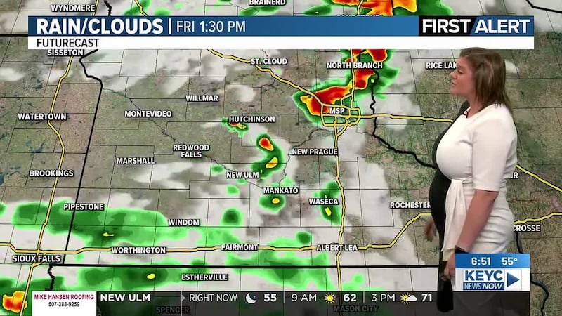
Friday will be the last cool day before we warm back up through the weekend. Skies will teeter between partly cloudy and mostly cloudy through the afternoon hours with another chance of sprinkles possible through the first half of the day. Though, most of the area will remain dry as temperatures top out in the low-50s with winds hovering between 10 and 15 mph, gusts up to 20 mph possible. Friday night will gradually become mostly clear as temperatures drop into the mid-30s by Saturday morning.
Saturday and Sunday will finally be a bit warmer, more seasonal with highs topping out in the low-60s on Saturday and the upper-60s on Sunday. Skies will teeter between mostly sunny and partly cloudy through the weekend with winds hovering between 5 and 15 mph, occasional gusts up to 20 mph possible. Overnight temperatures will also be a tad warmer, dropping into the mid to upper-40s by the following mornings.
Next week will continue with relatively dry conditions despite a chance of rain Tuesday night and Wednesday morning and afternoon. Aside from that, every other day will be on the drier side as dry air continues to blanket the area.
Those showers will be associated with a weak cold front, which will drop temperatures from the mid-60s on Monday to the mid to upper-50s Tuesday through Thursday. Skies will teeter between mostly sunny and partly cloudy for most of the week with mostly cloudy skies between Tuesday afternoon and Wednesday. Temperatures beyond Thursday will jump back into the mid to upper-60s for Friday and Saturday of next week/weekend as skies continue to teeter between mostly sunny and partly cloudy.
Winds throughout next week will be on the breezier side, averaging between 10 and 20 mph, gusts between 20 and 30 mph possible.
Overnight temperatures will likely drop into the mid to upper-30s and 40s by the following mornings.
Click here to download the KEYC News Now app or our KEYC First Alert weather app.
Copyright 2026 KEYC. All rights reserved.